Almanac And The Snow

  • Subscribe to our RSS feed.
  • Twitter
  • StumbleUpon
  • Reddit
  • Facebook
  • Digg

Tuesday, 18 December 2012

Severe Weather Update For Wed Night

Posted on 19:45 by Unknown
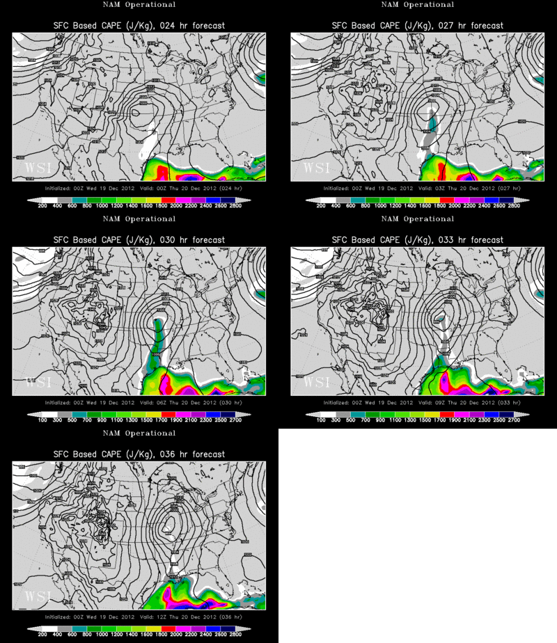
Here's a quick update on the chance for severe weather on Wednesday night into Thursday morning. As I said in the last post, the main ingredient that was lacking for severe weather was unstable air. The above image shows "CAPE" or the energy needed to drive severe storms. This animation covers the overnight hours. If you notice, the air is quite unstable early in the evening in SW Missouri and Western AR, but it fizzles as the night progresses.

What do I gather from this? Well, I thinking we will still see a squall line, but I think it will be DECAYING as it moves through Region 8. Let's hope so! I want to get a little sleep tomorrow night! (Selfish, I know)
Have a great night!
Ryan
Email ThisBlogThis!Share to XShare to FacebookShare to Pinterest
Posted in | No comments
Newer Post Older Post Home

0 comments:

Post a Comment

Subscribe to: Post Comments (Atom)

Popular Posts

  • Record Cold Start to May?
    If the last three runs of the GFS are correct, we could be quite chilly on Friday and Saturday. The GFS and Canadian model show the upper-le...
  • SPC Outlook for April 9th and 10th
    The Storm Prediction Center is a branch of NOAA and the NWS that issue outlooks on severe weather, severe weather watches, discussions on on...
  • Region 8 Fishing Forecast
    I recently talked with a gentleman in Walnut Ridge about fishing. He told me that the feeding activity of fish is largely dependent on the b...
  • One More Cold and Dreary Day!
    I'm so sick of the colder weather, but at least the colder weather yields no severe weather. It has been a LONG time since we have gone ...
  • Dead Birds and Radar.... Odd.
    What in the world is happening on radar in Beebe when thousands of birds fall from the sky? Does the radar show the birds? Does it show some...
  • A Look Back At April 10, 2013
    The above image was at 4:30 PM, when a tornado was confirmed SW of Clinton. Judging by the pics, it was a monster storm. That storm barely c...
  • Monday Evening Video Update
    I started video updates years ago and I'm going to try it again. I'm not sure I'm sold on doing video updates... but who knows. ...
  • Heavy Rain This Week
    I hope this is not a sign of things to come. I've had several friends that are farmers lately ask if we are going to see a wet and flood...
  • 2012 Compared to 1910
    The past 35 of 36 days have been above average. When showing the Almanac, I noticed that many of the record highs are from 1910, so I pulled...
  • Better Rain Chances
    We're transitioning to that time of the year when we look for the slightest little disturbance to spark off some storms. I calls these d...

Blog Archive

  • ►  2013 (39)
    • ►  August (1)
    • ►  July (1)
    • ►  June (1)
    • ►  May (4)
    • ►  April (5)
    • ►  March (10)
    • ►  February (7)
    • ►  January (10)
  • ▼  2012 (42)
    • ▼  December (15)
      • Snow Later? Models Agree
      • Mistlesnow, Monday 4:00 PM Update
      • Mistlesnow Update, Sunday 10PM
      • Mistlesnow Update, Sunday 5:00 PM
      • Ducks On Radar
      • How to Make a Snow Graphic!
      • Radar Confirmed?
      • Snow On Christmas Night?
      • Long Range Forecasting Is Tough
      • Severe Weather Update For Wed Night
      • Severe Weather Wednesday Night?
      • Snow Chances?
      • KAIT and RadarScope Partnership
      • Active Weather, Next 24 hours
      • Lots of Rain Soon?
    • ►  November (5)
    • ►  September (2)
    • ►  August (3)
    • ►  July (2)
    • ►  June (2)
    • ►  May (1)
    • ►  March (4)
    • ►  February (5)
    • ►  January (3)
  • ►  2011 (132)
    • ►  December (8)
    • ►  November (2)
    • ►  October (1)
    • ►  September (8)
    • ►  August (3)
    • ►  July (2)
    • ►  June (13)
    • ►  May (13)
    • ►  April (23)
    • ►  March (6)
    • ►  February (21)
    • ►  January (32)
  • ►  2010 (144)
    • ►  December (24)
    • ►  November (11)
    • ►  October (10)
    • ►  September (13)
    • ►  August (7)
    • ►  July (3)
    • ►  June (9)
    • ►  May (6)
    • ►  April (18)
    • ►  March (19)
    • ►  February (8)
    • ►  January (16)
  • ►  2009 (142)
    • ►  December (8)
    • ►  November (5)
    • ►  October (12)
    • ►  September (10)
    • ►  August (16)
    • ►  July (18)
    • ►  June (15)
    • ►  May (27)
    • ►  April (31)
Powered by Blogger.

About Me

Unknown
View my complete profile